Tropical Cyclone Maila, which developed at the beginning of April 2026, quickly evolved into a Category 4, becoming one of the strongest cyclones ever to occur in the Solomon Sea area. It has already hit the Solomon Islands and posed a high risk of flooding and winds to Papua New Guinea and northern Queensland, Australia.
On April 4, 2026, Severe Tropical Cyclone Maila developed in the warm waters of the Solomon Sea but initially remained almost stationary before moving west-southwest. This odd near-equatorial shape was in favour of high sea temperatures and thus grew rapidly to Category 4 on the Australian scale in a matter of days. As of April 10, it was continuing to pose threats as it made a complicated track forecast.
Formation and Path of Tropical Cyclone Maila
Maila was formed as a tropical low on April 4, and it slowly progressed without advancing and was stuck at the Solomon Islands until April 7. Thereafter, it hastened west-southwest and swept near the Western Province of the Solomons and headed towards the offshore Islands of Papua New Guinea, with a possible route sweeping towards the Cape York Peninsula of Queensland.
Bureau of Meteorology models forecasted a risk of landfall at or near Cooktown or Lockhart River during the period between April 14-15, but uncertainty increased after 72 hours.
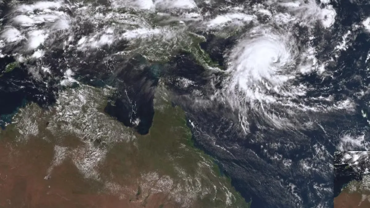
Intensity and Classification of the Cyclone
The cyclone reached its peak on April 7 when the winds were 145 mph (233 km/h) with a small, well-defined eye, which illuminated its explosive development. By April 9-10, it had slightly dropped to Category 3, having gusts of up to 210 km/h and a central pressure of about 960 hPa. The satellite images provided by the CIRA proved its small yet well-organised structure across.
Impacts and Warnings
With 115 mph winds, Maila struck the Western Province of Solomon Islands, causing evacuations, Tropical Cyclone Warning Number 17, and preliminary reports of damage such as flooded communities and power disruptions. Papua New Guinea was under a red warning of damaging gales, over 200 mm of rainfall, storm surges and waves up to 8.5 meters; Queensland preparedness was on the possibility of surges and flash flooding.
As of April 10, there were no fatalities, but disruptions continued.
Current Status
By April 10, 2026, Maila had been a Category 3 cyclone in the Solomon Sea, approximately 900 km east of Port Moresby, and was weakening but had the potential to reintensify over warm water. The coasts of Queensland are experiencing very little immediate impact, although watches can extend next week; the updates on the track are done every 6 hours through the BoM.
The National Emergency Operations Centre (NEOC) in Solomon Islands published situation reports on assessments and aid. The Queensland Get Ready program encouraged residents to watch the BOM applications, lock up homes and pack away evacuation kits during the late threat. International organisations, such as the one on ReliefWeb, led early response activities.


Comments
All Comments (0)
Join the conversation