Show Key Points
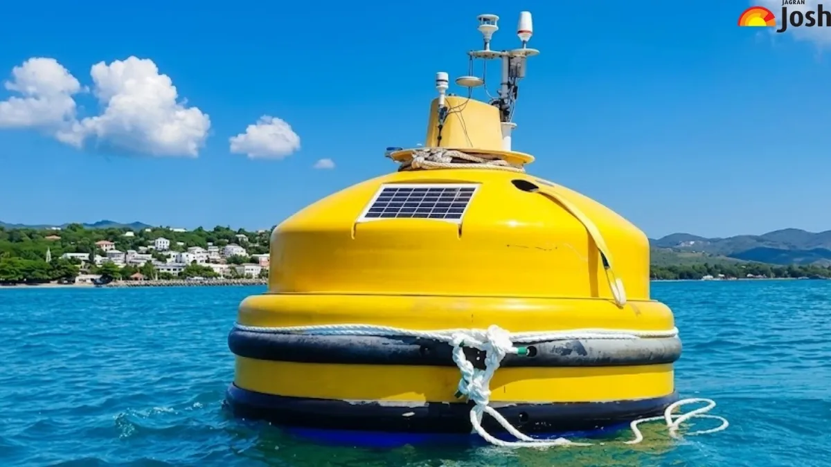
Floating Lidar Buoy System: National Institute of Ocean Technology (NIOT) has successfully tested an Indigenously built Floating LiDAR (Light Detection and Ranging) System off the Mutton Coast of Tamil Nadu. The system is a hightech Ocean-based tool to measure the wind condition over the sea up to 300 meters above sea level where traditional sensors can not reach.
What is the Floating LiDAR Buoy System?
Floating LiDAR Buoy System is a high-tech ocean based technology which is based on the remove-sensing technology mounted on a stabilised floating platform. It is mainly used for the measurement of the wind speed and direction over the sea level.
its key features include:
- High-Altitude Sensing: Measures wind profiles such as speed and directions from the surface up to 300 meters high which is significant to modern offshore wind turbines.
- Indigenous Technology: The System is developed and tested by National Institute of Ocean Technology(NIOT) which make India Self Reliance and reduces the reliance on imported systems.
- Autonomous Operation: the system is equipped with solar panels and wind turbines to provide a continuous self-sustaining power supply.
- Sustainability: The system is designed for harsh sea conditions such as salt environments, high waves and corrosive maritime conditions.
How is Floating LiDAR Buoy System Works?
- The system operates using laser-based technology.
- Laser Emission to send out pulses of infrared laser light into the sky.
- These light pulses (performs backscattering) hit microscopic particles in the air like aerosols, dust, or moisture carried by the wind.
- The light reflects off these particles and returns to the sensor due to the moving particles the frequency of the lights shifts which is known as Doppler Effect.
- During the shifts of the light the system calculates the exact speed and directions of winds at various altitudes.
- The system uses the Inertial Measurement Unit (IMU) to measure the buoy’s movements from the wind data to ensure the 99% accuracy.
What is the Significance?
The deployment of this system is a major leap forward for the renewable energy sector. Cost Efficiency by installing a fixed meteorological mast at sea can cost millions and this floating buoy provides the same data at 10-20% of the cost. Accurate wind data is collected which will boost the investors confidemce to invest offshore wind projects. A LiDAR buoy can be towed to different locations, allowing for the mapping of vast coastal stretches. It supports India’s goal of reaching 30 GW of offshore wind capacity by 2030, contributing to a greener and more self-reliant energy grid.
The National Institute of Ocean Technology (NIOT) successfully tested an indigenous Floating LiDAR Buoy System off Tamil Nadu's Mutton Coast. This high-tech ocean tool measures wind conditions up to 300 meters above sea level, crucial for offshore wind turbines. It offers cost-efficient, accurate wind data, boosting investor confidence and supporting India's 30 GW offshore wind capacity goal by 2030, enhancing self-reliance in renewable energy.
Also Read: What is Green Ammonia? Production, Uses, and Environmental Impact


Comments
All Comments (0)
Join the conversation