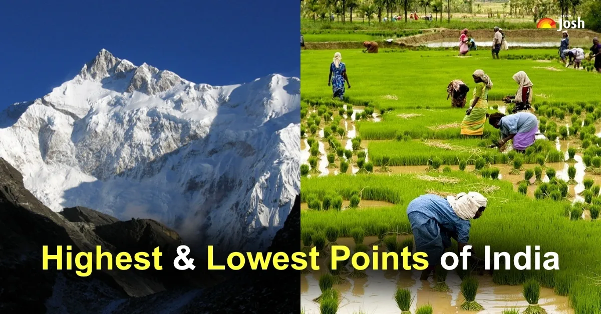
India is a land of stunning contrasts. From snow-covered mountains to golden deserts and lush forests to sparkling beaches, its natural beauty is truly breathtaking. Every corner of the country tells a different story. The landscapes are as diverse as its cultures and traditions. Among these wonders lie India's highest and lowest geographical points. The highest point is Kangchenjunga, standing tall at 8,586 metres. It is the third-highest mountain in the world and lies in the Himalayas, on the border of Sikkim and Nepal. Covered in snow year-round, it's a dream for mountaineers.
The lowest point is Kuttanad in Kerala, located about 2.2 metres below sea level. Known as the "Rice Bowl of Kerala", it's famous for its unique farming below sea level and scenic backwaters. In this article, we'll take a look at these two extremes of India's geography and explore what makes them so special.
Which is the Highest Altitude in India?

The highest altitude in India is Kangchenjunga, which stands at 8,586 metres (28,169 feet) above sea level.
10+ Fascinating Facts About Kangchenjunga
- Kangchenjunga is the third-highest mountain peak in the world, after Mount Everest and K2.
- It is located on the border between Sikkim (India) and Nepal in the Himalayan mountain range.
- The name Kangchenjunga means "The Five Treasures of Snow", referring to five sacred peaks associated with gold, silver, gems, grain, and holy books.
- The mountain massif features a unique cross-shaped ridge system, running northeast-southwest and east-west, which forms a significant watershed for several rivers.
- The massif features four main glaciers—Zemu, Talung, Yalung, and Kangchenjunga glaciers—each draining into critical river systems, including the Teesta, Arun, and Kosi.
- Kangchenjunga's rock composition primarily consists of high-grade metamorphic rocks, such as gneiss and schist, formed under intense heat and pressure deep within the Earth's crust.
- Igneous rocks, such as granite and pegmatite, as well as sedimentary rocks, including sandstone and limestone, are also present, indicating a complex geological history.

- The mountain formed through the tectonic collision of the Indian Plate with the Eurasian Plate starting around 50 million years ago, which continues to cause seismic activity and crustal deformation.
- The region experiences significant glacial retreat, a phenomenon linked to climate change, which affects water availability in downstream ecosystems.
- High-pressure and high-temperature metamorphic minerals, such as garnet, kyanite, and sillimanite, are found in the area, indicating the intense geological processes at work.
- Kangchenjunga influences regional climate patterns, as it is situated within the Brahmaputra and Ganges river basins, which are among the largest river systems influenced by the monsoon.
- The mountain's formation involves thrust faults such as the Main Central Thrust, a major geological boundary that shapes its structure and ongoing uplift.
- Kangchenjunga is part of a UNESCO World Heritage Site known as the Kangchenjunga Conservation Area.
- The region surrounding Kangchenjunga is home to rare and endangered flora and fauna, including the snow leopard and red panda.
Which is the Lowest Altitude in India?

The lowest altitude in India is found in Kuttanad, Kerala, which lies approximately 2.2 meters (about 7.2 feet) below sea level.
10+ Fascinating Facts About Kuttanad (Lowest Altitude in India)
- Kuttanad is one of the few places in the world where farming is practised below sea level, making it a unique geographic and agricultural region.
- It encompasses parts of the Alappuzha, Kottayam, and Pathanamthitta districts in Kerala.
- The region is primarily a river delta formed by the confluence of four principal rivers: Pamba, Meenachil, Achankovil, and Manimala.
- Kuttanad's below-sea-level farming is sustained by an intricate system of bunds (embankments) and canals that prevent flooding and control water levels.
- The land reclamation from the Vembanad Lake and surrounding wetlands has created vast paddy fields known as "puncha vayals".
- The soil in Kuttanad consists mainly of alluvial deposits, rich in nutrients and ideal for rice cultivation.
- Kuttanad's farming system utilises biosaline agriculture techniques to manage the saline conditions of reclaimed land.
- The region is recognised by the Food and Agriculture Organisation (FAO) as a Globally Important Agricultural Heritage System (GIAHS).

- Kuttanad lies adjacent to the Vembanad Lake, the longest lake in India, which plays a critical role in the region's hydrology and ecology.
- The region falls within the Vembanad-Kol wetland system, a Ramsar site recognised for its ecological importance, including biodiversity conservation and water purification functions.
- Kuttanad's below-sea-level farming is made possible by polderization—a scientific method of land reclamation that involves the construction of embankments to keep water out, supported by a system of canals and pumps to regulate water levels.
- The geological formation of Kuttanad is part of the extensive alluvial plains formed by sediment deposits from the Western Ghats, carried by rivers such as Pamba, Meenachil, and Achankovil.
- Kuttanad's wetlands exhibit a unique hydrology, with tidal influences from the Arabian Sea affecting salinity levels and necessitating the management of salinity in agriculture.
Disclaimer: Though Mount Kanchenjunga is widely recognized as the highest peak within India’s borders, standing tall at 8,586 meters, it’s important to note that K2, at 8,611 meters, surpasses it in elevation. K2 lies in the Gilgit-Baltistan region, which is administered by Pakistan but claimed by India as part of Jammu and Kashmir. From this perspective, K2 is technically India’s highest point. However, due to the complex geopolitical realities, Kanchenjunga remains the highest accessible peak from within India.
List of Other 7 High Altitude Points in India (Excluding Kanchenjunga and K2)
| Place/Point | State/Region | Elevation (Approx.) | Information |
| Nanda Devi | Uttarakhand | 7,816 m (25,643 ft) | The highest peak is entirely within India's undisputed territory. It is a part of the Garhwal Himalayas and is a UNESCO World Heritage Site. |
| Kamet | Uttarakhand | 7,756 m (25,446 ft) | The highest peak in the Zaskar Range and the third highest in India (after Kanchenjunga and Nanda Devi). It is located near the Tibetan plateau. |
| Saltoro Kangri | Ladakh (Karakoram Range) | 7,742 m (25,400 ft) | The highest peak of the Saltoro Mountains, a subrange of the Karakoram. It is located near the Siachen Glacier region. |
| Saser Kangri I | Ladakh (Karakoram Range) | 7,672 m (25,171 ft) | The highest of the Saser Kangri peaks, situated in the Saser Muztagh subrange of the Karakoram. |
| Mamostong Kangri | Ladakh (Karakoram Range) | 7,516 m (24,659 ft) | Part of the Rimo Muztagh subrange of the Karakoram, located in a remote area near the Siachen Glacier. |
| Rimo I | Ladakh (Karakoram Range) | 7,385 m (24,229 ft) | The highest peak of the Rimo Muztagh, part of the Great Karakoram Range. |
| Hardeol | Uttarakhand | 7,151 m (23,461 ft) | Located in the Kumaon Himalayas, it is often called the 'Temple of God' and lies on the northeast side of the ring of peaks guarding the Nanda Devi Sanctuary. |
| Chaukhamba I | Uttarakhand | 7,138 m (23,419 ft) | The highest peak of the four-summit Chaukhamba massif in the Gangotri Group of the Garhwal Himalayas. |
| Anamudi | Kerala | 2,695 m (8,842 ft) | The highest peak in the Western Ghats and the highest point in India outside the Himalaya-Karakoram mountain system. |
List of Other 7 Low Altitude Points in India (Excluding Kuttanad)
Given that Kuttanad is widely recognised as the lowest point in India (approx. −2.2 m below sea level), other notable low-altitude areas are often coastal plains or river deltas at or slightly above sea level. Many low points are localised areas on the coast or riverbeds at state borders, which are generally recorded as Sea Level (0 m) or slightly above.
| Place/Point | State/Region | Elevation (Approx.) | Information |
| Malabar Coast Lowlands | Kerala, Karnataka, Goa, T.N. | Near Sea Level (0 m) | This is the narrow coastal plain on the southwestern side of the Indian peninsula, characterised by extensive wetlands, estuaries, and backwaters (like the Vembanad Lake region). |
| Vembanad Lake | Kerala | Sea Level (0 m) | The longest lake in India and the largest lake in Kerala, forming a significant part of the Kerala Backwaters. It is at sea level. |
| Rann of Kutch (Great & Little) | Gujarat | Near Sea Level to ~15 m (50 ft) | A vast salt marsh that is often flooded during the monsoon, making it a very low-lying and seasonally inundated area close to the Arabian Sea. |
| Ganges River Delta | West Bengal | Near Sea Level (0 m) | A large delta region where the Ganges, Brahmaputra, and Meghna Rivers discharge into the Bay of Bengal, forming the world's largest delta and containing the Sundarbans mangrove forest. |
| Coastal Plains of Odisha | Odisha | Near Sea Level (0 m) | Flat alluvial deposits and the deltas of major rivers like the Mahanadi, Brahmani, and Baitarani characterise the region along the Bay of Bengal. |
| Coastal Andhra Plains | Andhra Pradesh | Near Sea Level (0 m) | The coastal area between the Eastern Ghats and the Bay of Bengal is characterised by river deltas like the Godavari and Krishna, which create flat, low-lying land. |
| Konkan Coastal Strip | Maharashtra, Goa, Karnataka | Near Sea Level (0 m) | The western coastal plain immediately to the north of the Malabar Coast is characterised by beaches, estuaries, and a narrow, low-elevation belt of land. |
| Point Calimere (Kodiakarai) | Tamil Nadu | Near Sea Level (0 m) | A low headland and wildlife sanctuary on the Coromandel Coast, a very low-lying coastal marsh area. |


Comments
All Comments (0)
Join the conversation