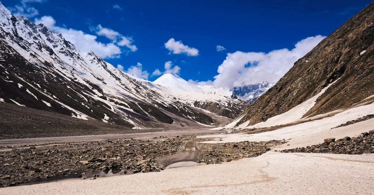
Mountain passes are natural routes through mountains that connect one region to another. In India, these passes have played a significant role in trade, travel, and defence since ancient times. They serve as essential gateways linking different states and even neighbouring countries. Mountain passes are often used by travellers, traders, and the Indian Army to cross high, rugged terrain. India, with its diverse landscape and mighty mountain ranges like the Himalayas, Karakoram, and Western Ghats, has many such vital passes.
Some are open all year, while others remain closed during winter due to heavy snowfall. There are more than 100 mountain passes across India, each with its own geographical and strategic importance. From the famous Zoji La in Jammu and Kashmir to Nathu La in Sikkim and Rohtang Pass in Himachal Pradesh, these routes connect valleys, states, and borders. In this article, we'll take a look at the list of important mountain passes in India, their locations, and why they hold such great significance for the country.
List of Mountain Passes in India
India is home to numerous mountain passes that connect remote valleys, facilitate trade, and play crucial roles in defence and tourism. These passes cut through major mountain ranges, including the Himalayas, the Karakoram, and the Western Ghats.
| State / Region | Mountain Pass | Elevation (m) | Connecting Between | Significance |
| Leh–Ladakh | Aghil Pass | 4,978 | Ladakh and Xinjiang (China) | Serves as an ancient link between India and China's Xinjiang region. Historically used for trade and travel across the Karakoram Range. Today, it remains strategically important for military patrols near the high-altitude frontier. |
| Bilafond La (Saltoro Pass) | 5,450 | Kashmir and China | Located near the Line of Control, it is vital for Indian defence operations in the Siachen Glacier region. Once part of the Silk Route, it's now an active military post on the Saltoro Ridge. | |
| Chang La | 5,391 | Leh and Changthang–Tibet | One of the world's highest motorable passes. Provides access from Leh to Pangong Lake and the Changthang Plateau. Crucial for defence logistics and scientific operations, including DRDO projects. | |
| Dehra Compass | 5,450 | India and the Tarim Basin (China) | A historic trade corridor linking India with the Tarim Basin. Once part of Central Asian trade networks. Although inactive now, it symbolises Indo-Central Asian cultural exchanges. | |
| Fotu La | 4,108 | Kargil and Leh | The highest pass on the Srinagar–Leh highway. Ensures year-round road connectivity between Kargil and Leh. Offers panoramic Himalayan views and supports both military and tourism movements. | |
| Imis La | 5,300 | Ladakh and Tibet | The ancient trade pass connecting India and Tibet. Opens into Hanle Valley, a site of religious and astronomical importance. Though less used now, it retains strategic relevance at the border. | |
| Karakoram Pass | 5,540 | Ladakh and Xinjiang (China) | Once a key point on the Silk Route, linking Leh to Yarkand. Now, a sensitive border area between India and China, known for extreme weather and strategic value. | |
| Khardung La | 5,359 | Leh and Nubra Valley | Among the world's highest motorable roads. Serves as a supply route for the Indian Army to Siachen Glacier and a popular tourist route for adventure seekers. | |
| Kongka Pass | 5,171 | Ladakh and Tibet (China) | Located on the Line of Actual Control, it witnessed clashes during the 1962 war. The area remains under close military surveillance due to ongoing geopolitical importance. | |
| Kaldang Kildang | 4,092 | Changthang and Nubra Valley | A remote pass used by nomadic herders for livestock migration. Holds cultural significance for local Changpa communities in Ladakh. | |
| Lanak Pass | 5,466 | Southeastern Ladakh and Western Tibet | Once a trade link between Tibet and Ladakh, it now lies near a disputed border region. Monitored for its defence relevance. | |
| Lungalacha La | 5,059 | Sarchu and Leh | A key stretch on the Manali–Leh Highway. Known for its high-altitude scenery and essential for transport, trade, and defence movement between Himachal and Ladakh. | |
| Marsimik La | 5,582 | Eastern Ladakh and Tibet | One of the highest motorable passes in the world, located near Pangong Lake. Plays a role in border defence and surveillance. Popular among adventure tourists. | |
| Namika La | 3,700 | Kargil and Leh | Also called "Pillar of the Sky." Lies on the Srinagar–Leh Highway and was part of ancient trade routes between Kashmir and Tibet. | |
| Parpik Pass | 5,570 | Kashmir and China | Lies near the trijunction of India, China, and Xinjiang. Historically crucial for trade and now significant for border monitoring. | |
| Pensi La | 4,400 | Kargil and Zanskar Valley | Known as the "Gateway to Zanskar”. Essential for transportation and tourism. Offers views of Drang-Drung Glacier. | |
| Renzang La | 5,059 | Southern Ladakh and Tibet | Site of the heroic Battle of Rezang La (1962). Symbol of Indian military bravery and a strategic border post. | |
| Sasser Pass | 5,411 | Nubra Valley and Yarkand (China) | Part of the ancient Silk Route connecting India with Central Asia. Now, it is strategically vital for military surveillance. | |
| Shashi La | 4,264 | Lalung Valley and Hagnis (Kargil) | A remote pass used mainly by shepherds and trekkers. Important for local livelihood and mountain exploration. | |
| Shingo La (Shinku La) | 5,091 | Zanskar and Lahaul (HP) | Historic trail now used for trekking. Offers access between Ladakh and Himachal; vital for local connectivity. | |
| Sia La | 5,589 | Siachen Glacier and Baltistan (Pakistan) | Critical pass near Siachen Glacier. Vital for India's defence in one of the world's highest military zones. | |
| Spanggur Gap | 4,900 | Western Ladakh and Tibet | Lies near Pangong Lake. Has strategic defence importance along the LAC. Witnessed confrontations in the 1962 war. | |
| Tanglang La | 5,328 | Leh and Manali | Among the highest passes in the world. Forms a crucial link for trade, tourism, and defence between Ladakh and Himachal Pradesh. | |
| Umling La | 5,799 | Chisumle and Demchok | The world's highest motorable pass. Built by BRO, connecting remote eastern Ladakh villages near the LAC. Symbol of India's engineering prowess. | |
| Jammu & Kashmir | Zoji La | 3,528 | Kashmir Valley and Ladakh | Strategic pass connecting Kashmir with Ladakh. Vital for military supplies and civilian travel. A tunnel under construction ensures year-round connectivity. |
| Pir Panjal Pass | 3,490 | Kashmir Valley and Rajouri–Poonch | Connects Kashmir with Jammu via the Mughal Road. Famous for trekking, alpine lakes, and scenic meadows. | |
| Banihal Pass | 2,832 | Banihal and Qazigund | Once a key link between Jammu and Srinagar. Known as the gateway to the Kashmir Valley, it is now bypassed by the Jawahar Tunnel. | |
| Himachal Pradesh | Rohtang Pass | 3,978 | Kullu and Lahaul–Spiti | Scenic mountain pass linking Kullu Valley with Lahaul-Spiti. Crucial for defence and tourism; gateway to Leh. |
| Shipki La | 3,930 | Kinnaur and Tibet | Trade route on the India–Tibet border. Restricted for civilians; used by Indian authorities for cross-border trade. | |
| Baralacha La | 4,850 | Lahaul and Leh | Lies on the Manali–Leh Highway. Important for cross-valley connectivity and tourism. | |
| Kunzum Pass | 4,551 | Lahaul and Spiti | Among India's highest motorable passes. Entry to Pin Valley National Park, a popular tourist and religious route. | |
| Saach Pass | 4,414 | Chamba and Pangi Valleys | Scenic, high-altitude route connecting remote regions. Offers spectacular mountain views. | |
| Pin Parvati Pass | 5,319 | Parvati and Spiti Valleys | Challenging trekking route linking lush Kullu with arid Spiti. Known for adventure tourism. | |
| Jalori Pass | 3,120 | Satluj and Tirthan Valleys | Renowned for its scenic beauty and hiking trails. Connects the interior valleys of Himachal. | |
| Uttarakhand | Mana Pass | 5,545 | Chamoli and Tibet | Among the world's highest motorable passes. Necessary for defence and pilgrims visiting the Nanda Devi Biosphere area. |
| Lipu Lekh | 5,115 | India–Tibet–Nepal | Strategic tri-junction; vital for the Kailash Mansarovar Yatra and Indo-China trade. | |
| Niti Pass | 5,086 | India and Tibet | Historic trade route; now used by the military for patrols and logistics. | |
| Traill's Pass | 5,300 | Kumaon and Garhwal | One of India's most challenging treks; it connects two mountain regions and glaciers. | |
| Borasu Pass | 5,450 | Har Ki Doon and Kinnaur | Old Indo-Tibetan trade link; now a famous trekking trail. | |
| Muling La | 5,669 | Pithoragarh and Nepal | Strategic military pass near the India–Nepal–Tibet junction. | |
| Kungri Bingri Pass | 5,540 | Chamoli and Tibet | Ancient trade route; used historically by Bhotiya traders for Indo-China commerce. | |
| Northeastern States | Bomdila Pass | 2,217 | Bomdila town, Arunachal Pradesh | Offers stunning Himalayan views. Important for regional travel and tourism. |
| Sela Pass | 4,170 | Tawang and Dirang | Sacred to Buddhists and a major tourist attraction. Key link to Tawang. | |
| Bum La Pass | 4,633 | Tawang and Tibet | Site of the 1962 war. Strategic Indo-China meeting point for border personnel. | |
| Diphu Pass | 4,587 | Arunachal Pradesh and Myanmar | The tri-junction of India, China, and Myanmar. Strategic importance for surveillance and trade. | |
| Pangsau Pass | 1,136 | Arunachal Pradesh and Myanmar | Part of the Stilwell Road was built during WWII. Links India with China through Myanmar. | |
| Nathu La | 4,310 | Sikkim and Tibet | Major Indo-China trade post. One of three open border crossings. | |
| Jelep La | 4,270 | Sikkim and Tibet | Historic trade route to Lhasa. Known for smooth terrain. | |
| Southern India | Palghat Gap | 140 | Tamil Nadu and Kerala | Low mountain gap in the Western Ghats. A central rail and road corridor between Coimbatore and Palakkad. |
| Shencottah Pass | 181 | Tenkasi (TN) and Kollam (Kerala) | The crucial pass connecting southern Tamil Nadu and Kerala for trade and transport. | |
| Thamarassery Pass | 800 | Kozhikode and Wayanad | Historical spice trade route. Renowned for its lush scenery and hairpin roads. | |
| Bisle Ghat | 840 | Hassan and Dakshina Kannada | Known for dense rainforests and biodiversity. Offers one of Karnataka's most scenic drives. | |
| Charmadi Ghat | 150 | Chikmagalur and Coastal Karnataka | Winding mountain pass with 25 hairpin bends. A vital road link and tourist attraction. |
1. Khardung La (Ladakh)
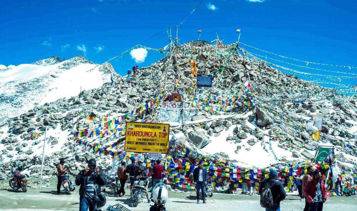
Khardung La, located in Ladakh at an altitude of about 5,359 meters, is one of the world's highest motorable passes. Built and maintained by the Border Roads Organisation, it was opened to vehicles in 1988. The pass connects Leh to the Nubra and Shyok Valleys and serves as the main route to the Siachen Glacier, making it vital for the Indian Army's supply lines.
2. Zoji La (Jammu & Kashmir)

Zoji La lies at 3,528 metres on the Srinagar–Leh Highway, linking the Kashmir Valley with Ladakh. Built during the British era and later improved by the Border Roads Organisation, this pass is the lifeline of Ladakh, ensuring the flow of supplies and troop movement even in harsh weather. It played a significant role in the 1947–48 war when Indian forces secured Ladakh through this route. Due to heavy snowfall, the pass often closes in winter. To address this, the government began construction of the Zoji La Tunnel in 2018 to provide all-weather connectivity to this vital border region.
3. Nathu La (Sikkim)

Nathu La, situated at 4,310 metres, connects Sikkim (India) with Tibet (China). Once part of the ancient Silk Route, it was reopened for trade in 2006 after being closed following the 1962 Indo-China War. It is one of the few officially open border passes between India and China, making it crucial for trade and diplomacy. The Indian Army also uses it for border patrols and logistics.
4. Rohtang Pass (Himachal Pradesh)
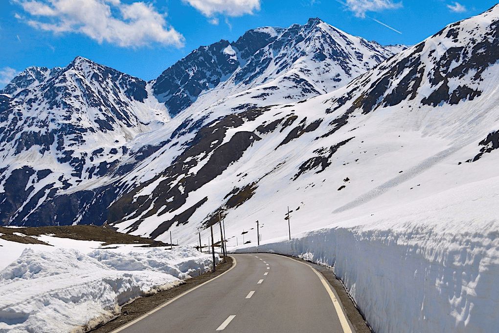
Rohtang Pass, located at 3,978 metres near Manali, connects Kullu Valley with Lahaul and Spiti. It has served as a key mountain route for centuries and was later developed by the Border Roads Organisation for military and civilian use. However, due to heavy snowfall, it remained closed for almost half the year. To overcome this, the Atal Tunnel, completed in 2020, was built under Rohtang Pass, ensuring all-season travel between Manali and Leh.
5. Lipu Lekh Pass (Uttarakhand)

Lipu Lekh Pass, at about 5,115 metres, lies at the trijunction of India, Nepal, and China in the Pithoragarh district of Uttarakhand. It has long been a route for trade and the famous Kailash Mansarovar Yatra to Tibet. The pass is of great strategic importance due to its location near the Indo-China border. The Border Roads Organisation maintains access roads that help the Indian Army move troops and supplies efficiently.
Why Mountain Passes Are Important

- Mountain passes act as natural gateways through high and rugged terrain, connecting distant valleys, regions, and even neighbouring countries that would otherwise remain isolated.
- For centuries, these routes have been vital for the exchange of goods like salt, wool, silk, and spices between India and nearby regions.
- Many passes lie near international borders, making them crucial for military movement, defence logistics, and national security.
- They attract travellers, trekkers, and adventure enthusiasts because of their breathtaking landscapes and challenging routes.
- Throughout history, these passes have promoted the exchange of people, ideas, and cultures between India, Tibet, and Central Asia, enriching regional traditions.
- Mountain passes support trade, transport, and communication in hilly and remote regions, boosting the local and border economies.
- They hold scientific and environmental importance, providing access to glaciers, unique plants, and fragile high-altitude ecosystems.
- During natural disasters or heavy snowfall, these routes often serve as the only means of delivering relief, medical aid, and essential supplies to isolated mountain communities.


Comments
All Comments (0)
Join the conversation