Hurricane Erin, the first Atlantic hurricane of 2025, reached a rare Category 5 hurricane in mid-August with winds of 160 mph before weakening to a Category 3 storm early Sunday, according to the National Hurricane Center. The storm underwent rapid intensification that surprised many forecasters, but has since brought strong winds and heavy rain to Puerto Rico and the Virgin Islands, with a tropical storm warning issued for the Turks and Caicos Islands. Although Erin is not expected to make landfall in the United States, its effects will be felt from Florida to New England, where rough surf, high waves, and dangerous rip currents USA remain a concern. Forecasters continue to use hurricane forecast models to track Erin’s evolving path and strength during the peak of the Atlantic storm 2025 season.
Read About- What are the Costliest Hurricanes in the U.S.? Check List!
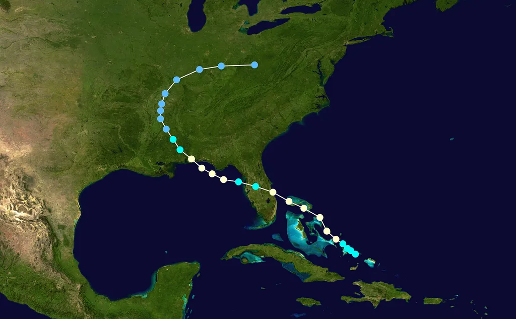
Where is Hurricane Erin Going to Hit?
According to the Hurricane Erin tracker, the storm, now a Category 3 hurricane, has already brought strong winds and heavy rains to Puerto Rico and the Virgin Islands, with a tropical storm warning issued for the Turks and Caicos Islands. Forecast hurricane spaghetti models still show Erin turning north into the open Atlantic and staying offshore, likely passing between North Carolina’s Outer Banks and Bermuda. While a direct U.S. landfall is not expected, forecasters caution that storm shifts remain possible, and coastal impacts such as dangerous surf and rip currents will continue along the East Coast.
| Location | Forecast Impact |
| East Coast (FL–NE) | High surf, dangerous rip currents |
| Outer Banks | Possible beach erosion, coastal flooding |
| Puerto Rico & Leeward Islands | Heavy rain, flash flooding |
How Will Hurricane Erin Impact the U.S. East Coast Beaches and Surf?
Even without landfall, Hurricane Erin US impact will be significant. The storm will produce dangerous surf along the East Coast, with waves exceeding 7 feet and strong rip currents between August 18–21. Coastal flooding and erosion are likely in vulnerable areas.
Why Did Hurricane Erin Intensify So Rapidly Into a Category 5 Storm?
Erin strengthened from a tropical storm to a Category 5 hurricane in just over 24 hours, a rare case of rapid intensification hurricane behavior. Favorable conditions such as warm Atlantic waters, low wind shear, and its distance from land fueled this explosive growth. At its peak, Erin reached sustained winds of 160 mph, qualifying as one of the strongest storms ever recorded this early in hurricane season August, according to the Saffir-Simpson scale. By Sunday, however, Erin had weakened to a Category 3 hurricane, with maximum sustained winds near 125 mph, while still posing risks of flooding rains, rough surf, and dangerous rip currents.
Must Read- What Were the Biggest Takeaways From Trump and Putin’s Meeting? Explained!
Conclusion
The story of Hurricane Erin is one of rapid growth and widespread impact, even without a direct U.S. landfall. With hurricane spaghetti models showing Erin’s track offshore, Americans should focus on coastal safety, avoiding rip currents, and monitoring updated forecasts. The storm underscores how quickly conditions can change during the Atlantic hurricane season, making preparedness vital. From its strength to its path, Erin is a reminder of the power and unpredictability of nature.


-1754308912274.jpg)

Comments
All Comments (0)
Join the conversation