

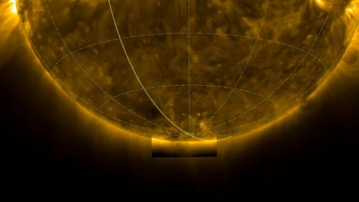
The European Space Agency’s (ESA) Solar Orbiter recently achieved a seismic scientific breakthrough, returning the first direct images of the Sun’s south polar region. This amazing success marks a monumental advance in our capacity to map these otherwise unseen areas.
Until now, every solar observation has focused on the Sun’s equatorial view from the Earth’s perspective. Combined with a series of gravity assists from Venus, the Solar Orbiter has tilted its orbit to provide it a truly unique vantage point. These initial pictures are yielding new, key understandings of the configuration of the magnetic field of the Sun and the detailed structure of its complex, 11-year solar cycle, in particular, during this, its current period of maximum activity, where north and south polarities are coexisting at the pole.
🌞 See the Sun from a whole new angle.
— European Space Agency (@esa) June 11, 2025
For the first time, our Solar Orbiter mission has captured close-up images of the Sun’s mysterious poles, regions long hidden from our view.
In 2025, Solar Orbiter gave us a first-ever look at the Sun’s south pole.
Remarkably, it… pic.twitter.com/EhyYxtDyaR
Check Out:What is Gold Card Visa? Check Launch Date and Key Details
Mission Basic Information
The Solar Orbiter spacecraft belongs to the European Space Agency and entered space in February 2020 through a partnership with NASA.
The image became publicly available in June 2025 after a detailed analysis of the data obtained during a close solar orbit in March 2024.
The Orbiter adjusted its orbital path through multiple Venus gravity assists to achieve unmatched observations of the solar poles.
The Extreme Ultraviolet Imager (EUI) and Polarimetric and Helioseismic Imager (PHI) instruments installed on the Orbiter captured the image.
Key Details of the Mission
Spacecraft: ESA’s Solar Orbiter, launched in February 2020 in collaboration with NASA.
Capture Date: The image was taken during a close solar flyby in March 2024 but was released publicly in June 2025 after thorough processing and analysis.
Method: The Orbiter gradually tilted its orbit over time using Venus’s gravity assists to gain an unprecedented view of the solar poles.
Instruments Used: The image was taken using the Extreme Ultraviolet Imager (EUI) and Polarimetric and Helioseismic Imager (PHI) aboard the Orbiter.
Significance of the Image
Uncharted Territory: Observation of the solar poles has not been possible because Earth-based telescopes cannot view through the Sun's equatorial plane. The Sun's south pole has been visually documented for the first time ever through direct observation, which shows unfamiliar structures and activities..
Getting a Grip on Solar Cycles: The Sun's magnetic field flips because of what happens at its poles, which kick off the 11-year solar cycle. By keeping an eye on what's going on at the poles, scientists can guess what future solar cycles might look like and how they'll affect space weather.
Better Space Weather Forecasts: When the Sun's poles get active, it leads to solar storms and huge eruptions called coronal mass ejections (CMEs). These can mess with Earth's communication and navigation systems. The info scientists gather helps them to make more accurate predictions about when these events might occur.
Magnetic Field Mapping: Scientists obtain better magnetic field maps of the Sun after capturing south pole images, which reveal how this field impacts solar system bodies.
What's Next?
The Solar Orbiter will modify its orbit path until 2026 to reach higher latitudes, thus enabling more detailed polar images. The mission has the potential to advance heliophysics by closing gaps in our solar behavior models and their extensive impacts.

-(1)-1750333945608.jpg)

-1750336283501.png)